WP5. Newcastle - the Demonstration City
In 2015, the Blue-Green Cities team transferred their research to Newcastle upon Tyne. Through discussion with the Newcastle Learning and Action Alliance, two areas were selected for detailed study; 1) the middle Ouseburn and Newcastle Great Park, and 2) the urban core and adjoining residential area of Wingrove.
Objective:
Deploy and demonstrate the applicability of the methods, measures and evaluations developed in WPs 1-4 in an urban location with hydrological, topographic, urban density, and socio-economic conditions that are representative of those found more widely in UK cities.
Key findings - middle Ouseburn and Newcastle Great Park
- Flood inundation modelling showed that the Newcastle Great Park SuDS ponds reduce flood risk in the local area
- Hydrodynamic sediment modelling showed that the SuDS ponds can trap large quantities of sediment washed in from further up catchment, reducing sediment input into the Ouseburn watercourse
- 54% of suspended sediment transported into a sampled SuDS pond is retained; this demonstrates that sediment entering SuDS assets is not stationary once deposited but is resuspended over multiple rainfall events (this differs to design standards that assume ~80% deposition)
- As designed, the sampled SuDS pond is actively retaining heavy metals (cadmium, zinc and lead)
- The sampled SuDS pond provides beneficial ecosystem improvement by supporting increasing macroinvertebrate species richness (which increases from the inlet to outlet)
- 90% of residents’ surveyed (299 total responses) like the SuDS ponds and 61% understand the role of the ponds in reducing flood risk; opinions on the aesthetic appeal varied (from ‘softens landscape’ to ‘scruffy’)
- In the non-flood condition the SuDS ponds provide benefits to carbon sequestration and habitat size, and reduce air pollution, noise and flood risk
- Opportunities for natural flood management in the Ouseburn catchment would further reduce flood risk, improve water quality and biodiversity
Key findings - Newcastle urban core and Wingrove
- Flood inundation simulations (using the coupled surface-subsurface CityCAT model) showed that the inclusion of Blue-Green infrastructure (e.g. green roofs, permeable paving, a large swale along St James’ Boulevard, greenspace and water butts) reduced flood risk under a range of event scenarios
- When interviewed, institutional stakeholders suggested that key barriers to the implementation of Blue-Green infrastructure in the urban core include a reluctance to support novel (new) approaches and change practices, lack of knowledge, and funding constraints. Ideas to overcome these barriers focus on promoting multifunctional space and improving understanding of non-technical stakeholders, including decision makers
- Multiple benefit evaluation shows that hypothetical Blue-Green infrastructure in Wingrove would reduc enoise and air pollution, increase carbon sequestration and habitat size, and improve access to greenspace for residents
- Multiple benefit evaluation suggests adding Blue-Green infrastructure to the urban core would provide additional carbon sequestration, increase access to greenspace (and provide a network of Blue-Green space through the city), increase habitat size and reduce air and noise pollution
- The flood footprint (direct plus indirect damages) of the 2012 ‘Toon monsoon’ is estimated at causing £78 million damage to the local economy (£34 m direct and £44 min direct damages)
Why Newcastle?
We (via Chris Kilsby at Newcastle University) have a long-standing partnership with Newcastle City Council (Lead Local Flood Authority (LLFA) for Newcastle), the University Estates Department, Environment Agency and Northumbrian Water (NWL), who were keen to work with us to identify suitable measures for surface water management following the severe flooding in summer 2012.
- Newcastle experienced major flooding events in June (Toon Monsoon) and August 2012 (both ~100 year return period).
- Newcastle is vulnerable to flash floods as 92% of the city centre surface is impermeable.
- Local drainage systems are often unable to cope with high volumes of rain over short periods.
- New strategies for removing surface water from combined sewers are required to free up capacity and enable the drainage system to cope with future expansion.
- Lots of interest in Blue-Green strategies for flood risk management from key stakeholder groups (Newcastle City Council, Northumbrian Water, Newcastle University, Environment Agency, architects, land owners and consultants) especially after the launch of the ‘Flood Force’ film.
Identified Hotspots for Surface Water Flooding
The NewcastleGateshead Surface Water Management Plan; Identifying
Areas at Risk Report

(55.6 MB), has identified 37 hotspots in Newcastle at risk of surface water flooding.
Several of the top 9 prioritised hotspots were studied by the Blue-Green Cities project, e.g. Hotspot NH15 City Centre – Central and East. This includes Newcastle City Centre, the Town Moor (likely to be saturated during extreme events) and Richardson Road, adjacent to the Leazes.
Hotspot NH15 City Centre - Central and East:
- Key flood risks due to urbanisation of the hotspot and high level of surface water ponding
- Several overland flow pathways have been identified, and are a product of rainfall on impermeable surfaces and extreme rainfall exceeding the capacity of the existing drainage system
- Localised flood problems associated with drainage gullies
- Part of the hotspot has been identified as a green infrastructure opportunity area
- 447 properties are at risk of flooding
- 14 critical infrastructure locations also at risk of flooding; 2 sections of railway line, 8 roads, 1 infirmary, 1 university and 2 stations
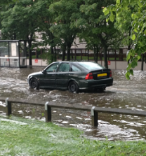
Flooding image from Newcastle City council report on Summer 2012 Flooding


Green Infrastructure and Flood Risk Management Strategies
There are also several Green Infrastructure initiatives planned for Newcastle, often in wider schemes looking at regeneration, climate change adaptation and mitigation that are funded by the LAs and other governmental bodies, including;
Plus there are many examples of existing green infrastructure and SuDS (e.g. storage ponds in images below).
WP5 was led by
Colin Thorne and
Emily O'Donnell (
University of Nottingham), and supported by the team.