WP3. Flood Risk Management Components and Interfaces
Flood risk management (FRM) components are part of a wider complex “system of systems” providing vital services for urban communities. The physical interfaces can be tracked by following flood pathways to controlled storage features and analysing planned interactions between urban stormwater and Blue-Green infrastructure.
Aims
- Understand the effects of FRM strategies incorporating Blue-Green infrastructure at a range of spatial and temporal scales
- Appraise the potential for positive and negative interactions with wider urban infrastructure
- Contextualise opportunities for Blue-Green infrastructure within the wider built environment and identify best practice of integrated urban planning (e.g. San Francisco Better Streets Plan)
- Develop a wider understanding of economic impacts of floods at higher spatial scales through a flood footprint analysis
Key findings
- Organisational complexity between responsible bodies has not reflected new interdependencies created by SuDS/GI solutions
- Responsibilities for SuDS and GI are largely separated by different groups responsible for their design and maintenance
- There is a state of policy disconnection which acts as a key barrier towards the effective adoption of SuDS/GI relating to physical barriers, perception/ information barriers and organisational barriers
- Optimising around one function of SuDS/GI can reduce other functions thus creating conflicts amongst disparate stakeholder groups
- See Hoang and Fenner (2015), System interactions of stormwater management using sustainable urban drainage systems and green infrastructure, Urban Water Journal
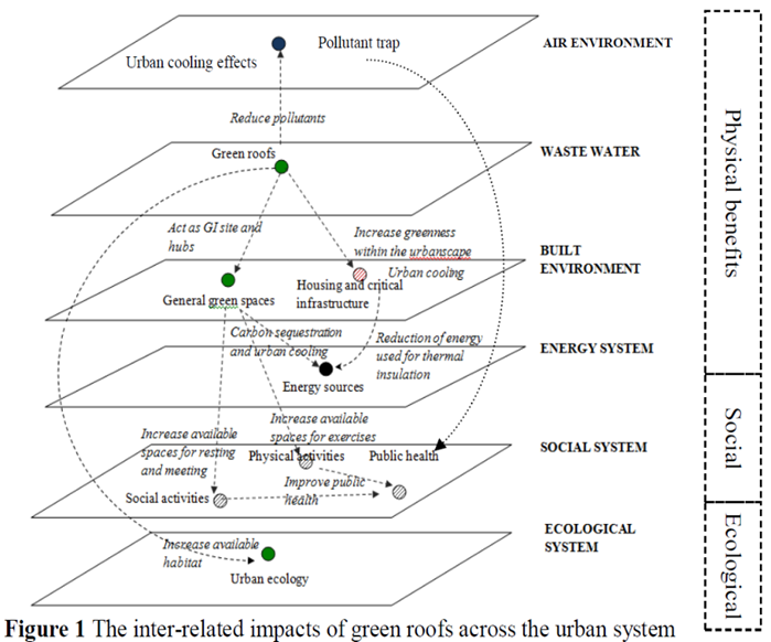
From Hoang and Fenner, 2015.
Flood footprint assessment
A flood footprint accounting tool has been developed to measure the cascading economic impact through multi-coupled economic systems, triggered by flooding adaptation measures, through to global and international scales.
The Flood Footprint framework can be used to optimise investment in Blue-Green infrastructure by identifying the blind-spots in critical infrastructure and vulnerable sectors in economic supply chains and social networks.
For further information please contact Dabo Guan.
The WP3 team comprised Dick Fenner and Lan Hoang (University of Cambridge), Dabo Gaun and David Mendoza (University of East Anglia), Colin Thorne and Emily O'Donnell (University of Nottingham).